
File:Tad Hang waterfalls at sunset, Tad Lo village, Bolaven Plateau, Laos.jpg

Size of this preview: 800 × 533 pixels. Other resolutions: 320 × 213 pixels | 6,440 × 4,293 pixels.
Original file (6,440 × 4,293 pixels, file size: 9.85 MB, MIME type: image/jpeg)
Summary
| Description |
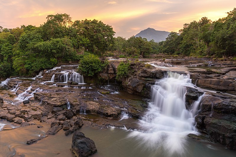
Français : Chutes de Tad Hang au coucher du soleil, village de Tad Lo, Plateau des Bolovens, Province de Saravane, Laos. |
| Date | |
| Source | Own work |
| Author | Basile Morin |
| Camera location | | View this and other nearby images on: OpenStreetMap |
|---|
|
Licensing
I, the copyright holder of this work, hereby publish it under the following license:
This file is licensed under the Creative Commons Attribution-Share Alike 4.0 International license.
- You are free:
- to share – to copy, distribute and transmit the work
- to remix – to adapt the work
- Under the following conditions:
- attribution – You must give appropriate credit, provide a link to the license, and indicate if changes were made. You may do so in any reasonable manner, but not in any way that suggests the licensor endorses you or your use.
- share alike – If you remix, transform, or build upon the material, you must distribute your contributions under the same or compatible license as the original.
File history
Click on a date/time to view the file as it appeared at that time.
| Date/Time | Thumbnail | Dimensions | User | Comment | |
|---|---|---|---|---|---|
| current | 04:30, 13 October 2019 | | 6,440 × 4,293 (9.85 MB) | Basile Morin | User created page with UploadWizard |
File usage
The following page uses this file: