File:JR East Shinkansen lineup at Niigata Depot 201210.jpg
Jump to: navigation, search
Size of this preview: 800 × 492 pixels. Other resolutions: 320 × 197 pixels | 3,488 × 2,144 pixels.
Original file (3,488 × 2,144 pixels, file size: 1,003 KB, MIME type: image/jpeg)
This file is from Wikimedia Commons and may be used by other projects. The description on its file description page there is shown below.
Summary
DescriptionJR East Shinkansen lineup at Niigata Depot 201210.jpg |
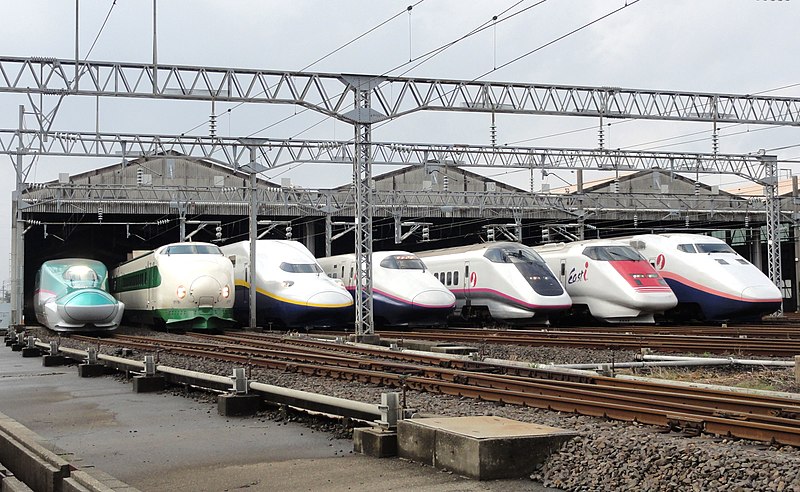
English: JR East Shinkansen Lineup on a Public opening Event (the 30th Anniversary of the Jōetsu Shinkansen) at Niigata Shinkansen Rolling Stock Center / (from the Left) E5 Series,
200 Series, E4 Series, E2 Series, E3 Series, E926 Type (East i), and E1 Series
|
Date | |
Source | Own work |
Author | Rsa |
Camera location | 37° 54′ 41.99″ N, 139° 06′ 37.25″ E | View this and other nearby images on: OpenStreetMap | 37.911665; 139.110348 |
---|
Licensing
I, the copyright holder of this work, hereby publish it under the following licenses:
Permission is granted to copy, distribute and/or modify this document under the terms of the GNU Free Documentation License, Version 1.2 or any later version published by the Free Software Foundation; with no Invariant Sections, no Front-Cover Texts, and no Back-Cover Texts. A copy of the license is included in the section entitled GNU Free Documentation License.http://www.gnu.org/copyleft/fdl.htmlGFDLGNU Free Documentation Licensetruetrue |
This file is licensed under the Creative Commons Attribution-Share Alike 3.0 Unported license. | ||
| ||
This licensing tag was added to this file as part of the GFDL licensing update.http://creativecommons.org/licenses/by-sa/3.0/CC BY-SA 3.0Creative Commons Attribution-Share Alike 3.0truetrue |
You may select the license of your choice.
Items portrayed in this file
depicts
21 October 2012
37°54'41.994"N, 139°6'37.253"E
File history
Click on a date/time to view the file as it appeared at that time.
Date/Time | Thumbnail | Dimensions | User | Comment | |
---|---|---|---|---|---|
current | 13:30, 21 October 2012 | 3,488 × 2,144 (1,003 KB) | Rsa | == {{int:filedesc}} == {{Information |Description=上越新幹線開業30周年記念イベント 新潟新幹線車両センター公開 |Source=Rsaが撮影 |Date=2012-10-21 |Author=Rsa |Permission=GFDL }} == ... |
File usage
The following page uses this file:
Metadata
This file contains additional information, probably added from the digital camera or scanner used to create or digitize it.
If the file has been modified from its original state, some details may not fully reflect the modified file.
Camera manufacturer | SONY |
---|---|
Camera model | DSC-HX5V |
Exposure time | 1/125 sec (0.008) |
F Number | f/10 |
ISO speed rating | 125 |
Date and time of data generation | 10:48, 21 October 2012 |
Lens focal length | 7.91 mm |
Latitude | 37° 54′ 41.99″ N |
Longitude | 139° 6′ 37.25″ E |
Altitude | 1.6 meters below sea level |
Orientation | Normal |
Horizontal resolution | 72 dpi |
Vertical resolution | 72 dpi |
File change date and time | 10:48, 21 October 2012 |
Y and C positioning | Co-sited |
Exposure Program | Normal program |
Exif version | 2.21 |
Date and time of digitizing | 10:48, 21 October 2012 |
Meaning of each component |
|
Image compression mode | 4 |
APEX exposure bias | 0 |
Maximum land aperture | 3.625 APEX (f/3.51) |
Metering mode | Pattern |
Light source | Unknown |
Flash | Flash did not fire, compulsory flash suppression |
Supported Flashpix version | 0,100 |
Color space | sRGB |
File source | Digital still camera |
Scene type | A directly photographed image |
Custom image processing | Normal process |
Exposure mode | Auto exposure |
White balance | Auto white balance |
Scene capture type | Landscape |
Contrast | Normal |
Saturation | Normal |
Sharpness | Normal |
GPS time (atomic clock) | 01:48 |
Receiver status | Measurement in progress |
Measurement mode | 3-dimensional measurement |
Speed unit | Kilometers per hour |
Speed of GPS receiver | 0.1 |
Reference for direction of movement | True direction |
Direction of movement | 197.46 |
Reference for direction of image | Magnetic direction |
Direction of image | 250.75 |
Geodetic survey data used | WGS-84 |
GPS date | 21 October 2012 |
GPS differential correction | 0 |
GPS tag version | 0.0.2.2 |