
File:Waterfront and downtown Louisville Kentucky USA Ohio River mile 604 July 1995 file 95g006.jpg

Original file (6,144 × 4,096 pixels, file size: 5.93 MB, MIME type: image/jpeg)
Summary
| Description |
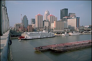
English: Waterfront and downtown Louisville, Kentucky, USA, on Ohio River at mile 604
View looking south-southwest from Clark (2nd St.) Bridge July 1, 1995 |
| Date | |
| Source | Own work |
| Author | William Alden III |
| Camera location | | View this and other nearby images on: OpenStreetMap |
|---|
Looking SSW from Clark (2nd St.) Bridge between railing posts #290 and #291
Steamer "American Queen" (doc. # 1030765), "Mayor Andrew Broaddus" (wharf boat), "Zachary Taylor II" (Boy Scouts boat) and steamer "Belle of Louisville" (doc. # 212813) at wharf.
Tow of "Valvoline" (including barges "AO 99" and "AO B-203") upbound.
As I recall, this was the first visit of the recently-completed "American Queen" to Louisville.
Ohio River mile 604
Louisville, Kentucky, USA
1-July-1995
file # 95g006
72 MB Photo CD #4, img0007
scanned from 6x9 cm Kodachrome
JPEG quality 95
Licensing
- You are free:
- to share – to copy, distribute and transmit the work
- to remix – to adapt the work
- Under the following conditions:
- attribution – You must give appropriate credit, provide a link to the license, and indicate if changes were made. You may do so in any reasonable manner, but not in any way that suggests the licensor endorses you or your use.
- share alike – If you remix, transform, or build upon the material, you must distribute your contributions under the same or compatible license as the original.
File history
Click on a date/time to view the file as it appeared at that time.
| Date/Time | Thumbnail | Dimensions | User | Comment | |
|---|---|---|---|---|---|
| current | 15:27, 21 April 2018 | | 6,144 × 4,096 (5.93 MB) | William Alden | User created page with UploadWizard |
File usage
The following page uses this file: