
File:Water taxies Brunei. (14333164242).jpg

Size of this preview: 800 × 525 pixels. Other resolutions: 320 × 210 pixels | 1,024 × 672 pixels.
Original file (1,024 × 672 pixels, file size: 596 KB, MIME type: image/jpeg)
Summary
| Description |
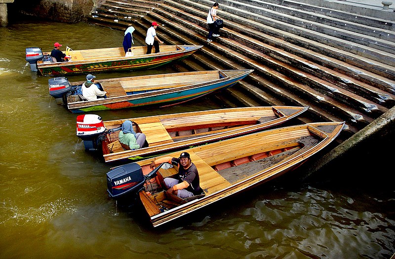
Brunei's water taxi links the Bandar Seri Begawan's waterfront to the wonderful water village of Kampung Ayer These water taxis ply along the Brunei River and can easily be hailed from different docking points along the river banks. You should be prepared to negotiate on the fares. The water taxis resemble wooden speed boats. These water taxis can take you around the water village. Speedboats are available for travelling to Temburong, a district of Brunei. These speedboats can easily be distinguished because of their blue colour. Travelling in one of the Brunei's water taxis is a unique experience, one of its kinds. |
| Date | |
| Source | Water taxies Brunei. |
| Author | Bernard Spragg. NZ from Christchurch, New Zealand |
| Camera location | | View this and other nearby images on: OpenStreetMap |
|---|
.jpg¶ms=004.886928_N_0114.944844_E_globe:Earth_type:camera_source:Flickr_&language=en)
Licensing
| This file is made available under the Creative Commons CC0 1.0 Universal Public Domain Dedication. | |
| The person who associated a work with this deed has dedicated the work to the public domain by waiving all of their rights to the work worldwide under copyright law, including all related and neighboring rights, to the extent allowed by law. You can copy, modify, distribute and perform the work, even for commercial purposes, all without asking permission.
|
| This image was originally posted to Flickr by Bernard Spragg at https://flickr.com/photos/88123769@N02/14333164242. It was reviewed on 23 June 2017 by FlickreviewR and was confirmed to be licensed under the terms of the cc-zero. |
File history
Click on a date/time to view the file as it appeared at that time.
| Date/Time | Thumbnail | Dimensions | User | Comment | |
|---|---|---|---|---|---|
| current | 20:19, 23 June 2017 | | 1,024 × 672 (596 KB) | Ser Amantio di Nicolao | Transferred from Flickr via Flickr2Commons |
File usage
The following page uses this file:
.jpg)