
File:University of Nevada , Reno, Nevada (3162493896).jpg

Original file (1,280 × 960 pixels, file size: 219 KB, MIME type: image/jpeg)
Summary
| Description |
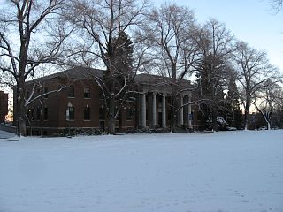
The University of Nevada, Reno (usually referred to as the University of Nevada or Nevada) is a teaching and research university established in 1874 and located in Reno, Nevada, USA. It is the sole land grant institution for the state of Nevada. The campus is home to the large-scale structures laboratory in the College of Engineering, which has put Nevada researchers at the forefront nationally in a wide range of civil engineering, earthquake and large-scale structures testing and modeling. The Nevada Terawatt Facility, located on a satellite campus of the university, includes a terawatt-level Z-pinch machine and terawatt-class high-intensity laser system – one of the most powerful such lasers on any college campus in the country. It is home to the University of Nevada School of Medicine, with campuses in both of Nevada's major urban centers, Las Vegas and Reno, and a health network that extends to much of rural Nevada. The faculty are considered worldwide and national leaders in diverse areas such as environmental literature, journalism, Basque studies, and social sciences such as psychology. It is also home to the Donald W. Reynolds School of Journalism, which has produced six Pulitzer Prize winners. The school includes 16 clinical departments and five nationally recognized basic science departments. University of Nevada, Reno is ranked 181st amongst national universities nationwide as a Tier 1 University by U.S. News & World Report. en.wikipedia.org/wiki/University_of_Nevada,_Reno en.wikipedia.org/wiki/Wikipedia:Text_of_Creative_Commons_... |
| Date | Taken on 26 December 2008, 17:18 |
| Source | University of Nevada , Reno, Nevada |
| Author | Ken Lund from Reno, Nevada, USA |
| Camera location | | View this and other nearby images on: OpenStreetMap |
|---|
.jpg¶ms=039.538568_N_-119.814324_E_globe:Earth_type:camera_source:Flickr_&language=en)
Licensing
- You are free:
- to share – to copy, distribute and transmit the work
- to remix – to adapt the work
- Under the following conditions:
- attribution – You must give appropriate credit, provide a link to the license, and indicate if changes were made. You may do so in any reasonable manner, but not in any way that suggests the licensor endorses you or your use.
- share alike – If you remix, transform, or build upon the material, you must distribute your contributions under the same or compatible license as the original.
| This image was originally posted to Flickr by Ken Lund at https://flickr.com/photos/75683070@N00/3162493896. It was reviewed on 5 December 2015 by FlickreviewR and was confirmed to be licensed under the terms of the cc-by-sa-2.0. |
File history
Click on a date/time to view the file as it appeared at that time.
| Date/Time | Thumbnail | Dimensions | User | Comment | |
|---|---|---|---|---|---|
| current | 21:55, 5 December 2015 | | 1,280 × 960 (219 KB) | INeverCry | Transferred from Flickr via Flickr2Commons |
File usage
The following page uses this file:
.jpg)