
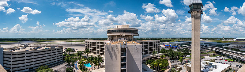
File:Tampa International Airport panorama (2015).jpg

Size of this preview: 800 × 235 pixels. Other resolutions: 320 × 94 pixels | 9,944 × 2,923 pixels.
Original file (9,944 × 2,923 pixels, file size: 23.74 MB, MIME type: image/jpeg)
Summary
| Description | Tampa International Airport panorama. |
| Date | |
| Source | TPA pano |
| Author | Don Miller from Venice, United States |
| Camera location | | View this and other nearby images on: OpenStreetMap |
|---|
.jpg¶ms=027.979924_N_-082.534554_E_globe:Earth_type:camera_source:Flickr_&language=en)
Licensing
This file is licensed under the Creative Commons Attribution 2.0 Generic license.
- You are free:
- to share – to copy, distribute and transmit the work
- to remix – to adapt the work
- Under the following conditions:
- attribution – You must give appropriate credit, provide a link to the license, and indicate if changes were made. You may do so in any reasonable manner, but not in any way that suggests the licensor endorses you or your use.
| This image was originally posted to Flickr by DonMiller_ToGo at https://www.flickr.com/photos/100899678@N06/17536972254. It was reviewed on 31 May 2015 by FlickreviewR and was confirmed to be licensed under the terms of the cc-by-2.0. |
File history
Click on a date/time to view the file as it appeared at that time.
| Date/Time | Thumbnail | Dimensions | User | Comment | |
|---|---|---|---|---|---|
| current | 23:37, 31 May 2015 | 9,944 × 2,923 (23.74 MB) | Magnolia677 | {{Information |Description=Tampa International Airport panorama. |Source=[https://www.flickr.com/photos/donmillertogo/17536972254/ TPA pano] |Date=2015-05-26 15:25 |Author=[https://www.flickr.com/people/100899678@N06 Don Miller] from Venice, United Sta... |
File usage
The following page uses this file:
.jpg)