
File:Sand Harbor, Lake Tahoe Nevada State Park, Incline Village, Nevada (21315986936).jpg

Original file (4,000 × 3,000 pixels, file size: 4.04 MB, MIME type: image/jpeg)
Summary
| Description |
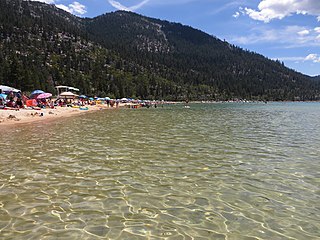
Lake Tahoe – Nevada State Park is a state park of Nevada, United States, on the northeast shores of Lake Tahoe. The park comprises six management units which total 14,301 acres (5,787 ha). The park is in the Western Nevada Region of Nevada State Parks. It includes the Marlette Lake Water System which is listed on the National Register of Historic Places and as a Historic Civil Engineering Landmark. Sand Harbor features a large sandy beach on Lake Tahoe's eastern shore. It is also the location of the outdoor Lake Tahoe Shakespeare Festival. Bouldering, picnicking, the Sand Point nature trail, a boat launch and the Lake Tahoe–Nevada State Park visitor center are all located here. en.wikipedia.org/wiki/Lake_Tahoe_%E2%80%93_Nevada_State_Park en.wikipedia.org/wiki/Wikipedia:Text_of_Creative_Commons_... |
| Date | Taken on 20 July 2015, 12:48 |
| Source | Sand Harbor, Lake Tahoe Nevada State Park, Incline Village, Nevada |
| Author | Ken Lund from Reno, Nevada, USA |
| Camera location | | View this and other nearby images on: OpenStreetMap |
|---|
.jpg¶ms=039.196483_N_-119.930956_E_globe:Earth_type:camera_source:Flickr_&language=en)
Licensing
- You are free:
- to share – to copy, distribute and transmit the work
- to remix – to adapt the work
- Under the following conditions:
- attribution – You must give appropriate credit, provide a link to the license, and indicate if changes were made. You may do so in any reasonable manner, but not in any way that suggests the licensor endorses you or your use.
- share alike – If you remix, transform, or build upon the material, you must distribute your contributions under the same or compatible license as the original.
| This image was originally posted to Flickr by Ken Lund at https://flickr.com/photos/75683070@N00/21315986936. It was reviewed on 5 December 2015 by FlickreviewR and was confirmed to be licensed under the terms of the cc-by-sa-2.0. |
File history
Click on a date/time to view the file as it appeared at that time.
| Date/Time | Thumbnail | Dimensions | User | Comment | |
|---|---|---|---|---|---|
| current | 22:19, 5 December 2015 | | 4,000 × 3,000 (4.04 MB) | INeverCry | Transferred from Flickr via Flickr2Commons |
File usage
The following page uses this file:
.jpg)