
File:Saint Lucia map (en).png

Size of this preview: 338 × 599 pixels. Other resolutions: 135 × 240 pixels | 1,693 × 3,001 pixels.
Original file (1,693 × 3,001 pixels, file size: 863 KB, MIME type: image/png)
Summary
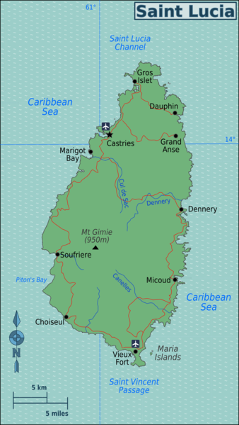
| Description | Map of Saint Lucia (Caribbean) for use on Wikivoyage, English version |
| Date | |
| Source | Own work based on the map of districts by MorbZ, Perry-Castañeda Library Map Collection St Lucia map, and OpenStreetMap |
| Author | Burmesedays |
| Other versions | SVG base file |
Licensing
This file is licensed under the Creative Commons Attribution-Share Alike 3.0 Unported license.
- You are free:
- to share – to copy, distribute and transmit the work
- to remix – to adapt the work
- Under the following conditions:
- attribution – You must give appropriate credit, provide a link to the license, and indicate if changes were made. You may do so in any reasonable manner, but not in any way that suggests the licensor endorses you or your use.
- share alike – If you remix, transform, or build upon the material, you must distribute your contributions under the same or compatible license as the original.
Original upload log
| This file was imported from Wikivoyage WTS. |
The original description page was here. All following user names refer to wts.wikivoyage-old.
.png)
- 2010-05-21 04:11 (WT-shared) Burmesedays[dead link] 961×1188 (208757 bytes) {{Imagecredit|credit=[[User:Burmesedays]], [http://de.wikipedia.org/wiki/User:MorbZ MorbZ], [http://lib.utexas.edu/maps/americas/saint_lucia (Import from wikitravel.org/shared)
- 2010-05-21 04:13 (WT-shared) Burmesedays[dead link] 1693×3001 (883653 bytes) whoops (Import from wikitravel.org/shared)
File history
Click on a date/time to view the file as it appeared at that time.
| Date/Time | Thumbnail | Dimensions | User | Comment | |
|---|---|---|---|---|---|
| current | 22:30, 25 November 2012 | | 1,693 × 3,001 (863 KB) | MGA73bot2 | {{BotMoveToCommons|wts.oldwikivoyage|year={{subst:CURRENTYEAR}}|month={{subst:CURRENTMONTHNAME}}|day={{subst:CURRENTDAY}}}} == {{int:filedesc}} == {{Information |description=Map of Saint Lucia. SVG, Saint Lucia * Map of: Saint Lucia¤ |date=May 18th 20... |
File usage
The following page uses this file:
.png)