
File:River Douro Valley Portugal - Vallée de la rivière Douro Portugal - Wine Vin Porto - Picture Image Photography (14962280582).jpg

Original file (2,999 × 4,498 pixels, file size: 14.37 MB, MIME type: image/jpeg)
Summary
| Description |
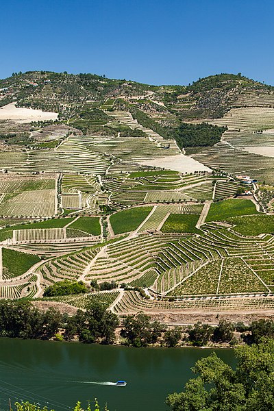
The Douro (Portuguese: Douro [ˈdowɾu, ˈdoɾu]; Spanish: Duero [ˈdweɾo]; Latin: Durius) is one of the major rivers of the Iberian Peninsula, flowing from its source near Duruelo de la Sierra in Soria Province across northern-central Spain and Portugal to its outlet at Porto. The name, Latinized Durius, may have come from the Celtic tribes that inhabited the area before Roman times: the Celtic root is *dubro- and in modern Welsh dŵr is "water" with cognate dobhar in Irish. In Roman times, the river was personified as a god, Durius. The Douro vinhateiro (=winegrowing), an area of the Douro Valley in Portugal, has been classified by UNESCO as a World Heritage Site. Traditionally, the wine was taken down river in flat-bottom boats called rabelos to be stored in barrels in cellars in Vila Nova de Gaia, just across the river from Porto. In the 1950s and 1960s, dams were built along the river ending this river traffic on Spanish and border sections. Now Port wine is transported in tanker trucks. It is the third longest river in the Iberian Peninsula after the Tagus and Ebro; its total length is 897 kilometres (557 mi), of which only sections of the Portuguese extension are navigable, by light rivercraft. In its Spanish section, the Douro crosses the great Castilian meseta and meanders through five provinces of the autonomous community of Castile and León: Soria, Burgos, Valladolid, Zamora, and Salamanca, passing through the towns of Soria, Almazán, Aranda de Duero, Tordesillas, and Zamora. In this region, there are few tributaries of the Douro. The most important are the Pisuerga, passing through Valladolid, and the Esla, which passes through Zamora. This region is generally semi-arid plains, with wheat and in some places, especially near Aranda de Duero, with vineyards, in the Ribera del Duero wine region. Sheep rearing is also still important. Then, for 112 kilometres (70 mi), the river forms part of the national border line between Spain and Portugal, in a region of narrow canyons, making it a historical barrier for invasions and a cultural/linguistic divide. In these isolated areas, in which the Aldeadávila Dam impounds the river, there are protected areas: the International Douro Natural Park (on the Portuguese side) and the Arribes del Duero Natural Park (on the Zamoran margin). The Douro fully enters Portuguese territory just after the confluence with the Águeda River; once the Douro enters Portugal, major population centres are less frequent. Except for Porto and Vila Nova de Gaia at the river mouth, the only population centres of any note are Foz do Tua, Pinhão and Peso da Régua. Tributaries here are small, merging into the Douro along the canyons; the most important are Côa, Tua, Sabor, Corgo, Tavora, Paiva, Tâmega, and Sousa. None of these small, fast flowing rivers are navigable. Major Spanish riverside towns include Soria, Almazán, Aranda de Duero, Tordesillas, Zamora and major Portuguese towns include Miranda do Douro, Foz Côa, Peso da Régua, Lamego, Vila Nova de Gaia, and Porto. The most populous cities along the Douro River are Valladolid, Zamora in Spain and Porto and Vila Nova de Gaia in Portugal. The latter two are located at the mouth of the Douro. In Portugal, the Douro flows through the districts of Bragança, Guarda, Viseu, Vila Real, Aveiro and Porto. Porto is the main hub city in northern Portugal and its historic centre is declared as a UNESCO monumental place. These reaches of the Douro have a microclimate allowing for cultivation of olives, almonds, and especially grapes that are important for making the famous Port wine. The region around Pinhão and São João da Pesqueira is considered to be the centre of Port wine, with its quintas (or farms/estates) that extend the almost vertical slopes along the river valleys. Many of these quintas are owned by multinational wine companies. Recently, a prosperous tourist industry has developed based on river excursions from Porto to points along the Upper Douro valley. There are five dams on the Portuguese Douro alone functioning to make the flow of water uniform, generate hydroelectric power, and allow navigation. Ships with a maximum length of 83 metres (272 ft) and width of 11.4 metres (37 ft) can pass through five locks. The highest one on Carrapatelo dam has a maximum lift of 35 metres (115 ft). Level of Pocinho lake reaches 125 m a.s.l. The Douro railway line (in Portuguese: Linha do Douro) was completed in 1887; it connects Porto, Rio Tinto, Ermesinde, Valongo, Paredes, Penafiel, Livração, Marco de Canaveses, Régua, Tua and Pocinho. Pocinho is near the city of Foz Côa, which is close to Côa Valley Paleolithic Art site, (an Archaeological pre-historic patrimony) another UNESCO Heritage Sight. دورو (بالبرتغالية: دورو [dowɾu، doɾu]. الإسبانية: دويرو [dweɾo]. اللاتينية: Durius) هو واحد من الأنهار الرئيسية في شبه الجزيرة الايبيرية، التي تتدفق من منبعه قرب Duruelo دي لا سييرا في مقاطعة سوريا عبر شمال ووسط أسبانيا والبرتغال إلى منفذ لها في بورتو. الاسم، Durius اللاتيني، قد تأتي من القبائل السلتية التي سكنت المنطقة قبل العصر الروماني: جذور سلتيك هو * dubro- وDWR الويلزية الحديث هو "المياه" مع dobhar وما شابه ذلك في الايرلندي. في العصر الروماني، وقد جسد النهر إلها، Durius. وvinhateiro دورو (= winegrowing)، وهي منطقة وادي دورو في البرتغال، تم تصنيف منظمة اليونسكو كموقع للتراث العالمي. تقليديا، تم اتخاذ النبيذ أسفل النهر في قوارب مسطحة القاع دعا rabelos ليتم تخزينها في براميل في أقبية في فيلا نوفا دي غايا، فقط عبر النهر من بورتو. في 1950s و 1960s، تم بناء السدود على طول نهر إنهاء حركة الملاحة النهرية هذا على أقسام الإسبانية والحدود. الآن يتم نقل ميناء النبيذ في الصهاريج. هو ثالث أطول نهر في شبه الجزيرة الايبيرية بعد التاجة وإيبرو. طولها الإجمالي 897 كيلومترا (557 ميل)، منها سوى أجزاء من التمديد هي البرتغالية للملاحة، من خلال rivercraft الضوء. في قسمها الإسبانية، دورو يعبر meseta القشتالية كبير وتعرجات من خلال خمس محافظات منطقة الحكم الذاتي لمنطقة قشتالة وليون: سوريا، بورغوس، بلد الوليد، زامورا، وسالامانكا، مرورا مدن سوريا، المزان، اراندا دى دويرو، توردسيلاس، وزامورا. في هذه المنطقة، هناك عدد قليل من روافد دورو. أهمها هي بيسويرجا، مرورا بلد الوليد، وEsla، الذي يمر عبر زامورا. هذه المنطقة هي عموما السهول شبه القاحلة، مع القمح وفي بعض الأماكن، وخاصة بالقرب اراندا دى دويرو، مع كروم العنب في منطقة النبيذ ريبيرا ديل دويرو. تربية الأغنام لا تزال مهمة أيضا. ثم، ل112 كيلومتر (70 ميل)، والنهر جزءا من خط الحدود الوطنية بين اسبانيا والبرتغال، في منطقة من الوديان الضيقة، مما يجعلها عائقا التاريخي للغزوات و/ الانقسام اللغوي الثقافي. دورو الحديقة الدولية الطبيعية (على الجانب البرتغالي) وArribes ديل دويرو بارك الطبيعية (على هامش Zamoran): في هذه المناطق المعزولة، والتي السد Aldeadávila impounds النهر، وهناك المناطق المحمية. دورو يدخل الأراضي البرتغالية تماما بعد التقاء مع نهر AGUEDA. بمجرد دخول دورو البرتغال، المراكز السكانية الرئيسية هي أقل تواترا. باستثناء بورتو وفيلا نوفا دي غايا عند مصب النهر، والمراكز السكانية الوحيدة لأي ملاحظة هي فوز دو توا، وPinhão بيزو دا Régua. هنا روافد صغيرة، والاندماج في دورو على طول الأخاديد. أهمها شهادة توثيق البرامج، توا، سابور، Corgo، تافورا، بايفا، Tâmega، وسوسا. أيا من هذه، الأنهار الصغيرة التي تتدفق بسرعة وللملاحة. وتشمل كبرى المدن الاسبانية النهر سوريا، المزان، اراندا دى دويرو، توردسيلاس، زامورا والبلدات البرتغالية الرئيسية تشمل ميراندا دو دورو، فوز جنة الزراعة، بيزو دا Régua، اميغو، فيلا نوفا دي غايا، وبورتو. المدن الأكثر اكتظاظا بالسكان على طول نهر دورو هي بلد الوليد، زامورا في اسبانيا وبورتو وفيلا نوفا دي غايا في البرتغال. وتقع الأخيرين عند مصب دورو. في البرتغال، يتدفق دورو عبر مناطق براغانزا، غواردا، فيسيو، فيلا ريال، افيرو وبورتو. بورتو هي المدينة المحور الرئيسي في شمال البرتغال وأعلن المركز التاريخي كمكان ضخمة اليونسكو. هذه الروافد من دورو لها مناخ يسمح لزراعة الزيتون واللوز والعنب وخصوصا التي تعتبر مهمة لصنع النبيذ ميناء الشهير. وتعتبر المنطقة المحيطة Pinhão وساو جواو دا بيسكيرا ليكون مركز ميناء النبيذ، مع كوينتاس لها (أو مزارع / العقارات) التي تمتد منحدرات عمودية تقريبا على طول وديان الأنهار. وتمتلك العديد من هذه كوينتاس من قبل الشركات متعددة الجنسيات النبيذ. في الآونة الأخيرة، طورت صناعة سياحية مزدهرة على أساس الرحلات النهر من بورتو إلى نقطة على طول وادي دورو العليا. هناك خمسة سدود على دورو البرتغالية وحده يعمل لجعل تدفق الماء موحدة، وتوليد الطاقة الكهرومائية، والسماح الملاحة. يمكن أن يأتي مع الحد الأقصى لطول 83 مترا (272 قدم) وعرض 11.4 متر (37 قدم) تمر من خلال خمسة أقفال. أعلى واحد على Carrapatelo السد لديه رفع الحد الأقصى من 35 مترا (115 قدم). مستوى Pocinho بحيرة يصل إلى 125 م a.s.l. خط السكة الحديد دورو (بالبرتغالية: ينها القيام دورو) واكتمل في عام 1887. أنه يربط بورتو وريو تينتو، Ermesinde، فالونجو، باريديس، بينافيل، Livração، ماركو دي Canaveses، Régua، توا وPocinho. Pocinho بالقرب من مدينة فوز دو جنة الزراعة، التي هي قريبة من وادي بسم العصر الحجري القديم الموقع الفن، (وهو تراث ما قبل التاريخ الأثري) آخر اليونسكو للتراث البصر. |
| Date | |
| Source | River Douro Valley Portugal - Vallée de la rivière Douro Portugal - Wine Vin Porto - Picture Image Photography |
| Author | Grand Parc - Bordeaux, France from France |
| Camera location | | View this and other nearby images on: OpenStreetMap |
|---|
.jpg¶ms=041.185565_N_-007.531986_E_globe:Earth_type:camera_source:Flickr_&language=en)
Licensing
- You are free:
- to share – to copy, distribute and transmit the work
- to remix – to adapt the work
- Under the following conditions:
- attribution – You must give appropriate credit, provide a link to the license, and indicate if changes were made. You may do so in any reasonable manner, but not in any way that suggests the licensor endorses you or your use.
| This image was originally posted to Flickr by Grand Parc - Bordeaux, France at https://www.flickr.com/photos/80641068@N07/14962280582. It was reviewed on 15 December 2014 by FlickreviewR and was confirmed to be licensed under the terms of the cc-by-2.0. |
File history
Click on a date/time to view the file as it appeared at that time.
| Date/Time | Thumbnail | Dimensions | User | Comment | |
|---|---|---|---|---|---|
| current | 20:29, 15 December 2014 | | 2,999 × 4,498 (14.37 MB) | Medium69 | Transferred from Flickr via Flickr2Commons |
File usage
The following page uses this file:
.jpg)