
File:Ranchos a la orilla de la playa La Mochila.jpg

Size of this preview: 800 × 600 pixels. Other resolutions: 320 × 240 pixels | 3,072 × 2,304 pixels.
Original file (3,072 × 2,304 pixels, file size: 1.54 MB, MIME type: image/jpeg)
Summary
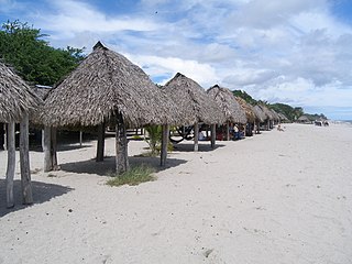
| Description | Ranchos turísticos a la orilla de la playa Santa Clara, Coclé | ||
| Date | |||
| Source |
Fundación Almanaque Azul
|
||
| Author | Mir Rodriguez | ||
| Permission (Reusing this file) |
This file is licensed under the Creative Commons Attribution-Share Alike 3.0 Unported license.
|
||
| mochila_relacion_programa_educativo | Los seres vivos y su ambiente | ||
| mochila_provincia | Coclé | ||
| mochila_distrito | Antón | ||
| mochila_corregimiento | Rio Hato | ||
| mochila_lugar | Santa Clara | ||
| mochila_georef_type | Centroide | ||
| mochila_ecosistema | Bosques Secos Panameños | ||
| mochila_grupos humanos | |||
| mochila_palabras_clave | Ranchos y playa | ||
| mochila_tema | Interacción hombre- ambiente | ||
| mochila_paisaje | Rural | ||
| mochila_nombre_comun | |||
| mochila_codigo_admin | 20207 | ||
| mochila_geologia | |||
| mochila_cuenca | Río Chame | ||
| mochila_SINAP |
| Camera location | | View this and other nearby images on: OpenStreetMap |
|---|
File history
Click on a date/time to view the file as it appeared at that time.
| Date/Time | Thumbnail | Dimensions | User | Comment | |
|---|---|---|---|---|---|
| current | 18:16, 28 July 2014 | | 3,072 × 2,304 (1.54 MB) | Ayaita | GWToolset: Creating mediafile for Ayaita. |
File usage
The following page uses this file: