
File:Río Medellín desde la Avenida 33, 2017.jpg

Size of this preview: 800 × 600 pixels. Other resolutions: 320 × 240 pixels | 4,160 × 3,120 pixels.
Original file (4,160 × 3,120 pixels, file size: 1.58 MB, MIME type: image/jpeg)
Summary
| Description |
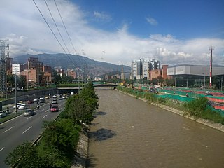
Español: Vista del río Medellín hacia el norte desde el puente que lo cruza a la altura de la Avenida 33, en noviembre de 2017. Se aprecian el soterrado de la Avenida Regional al occidente (izquierda de la imagen) y las obras de Parques del Río (oriente, a la derecha) |
| Date | |
| Source | Own work |
| Author | XalD |
| Camera location | | View this and other nearby images on: OpenStreetMap |
|---|
Licensing
I, the copyright holder of this work, hereby publish it under the following license:
This file is licensed under the Creative Commons Attribution-Share Alike 4.0 International license.
- You are free:
- to share – to copy, distribute and transmit the work
- to remix – to adapt the work
- Under the following conditions:
- attribution – You must give appropriate credit, provide a link to the license, and indicate if changes were made. You may do so in any reasonable manner, but not in any way that suggests the licensor endorses you or your use.
- share alike – If you remix, transform, or build upon the material, you must distribute your contributions under the same or compatible license as the original.
File history
Click on a date/time to view the file as it appeared at that time.
| Date/Time | Thumbnail | Dimensions | User | Comment | |
|---|---|---|---|---|---|
| current | 01:10, 26 March 2018 | | 4,160 × 3,120 (1.58 MB) | XalD | User created page with UploadWizard |
File usage
The following page uses this file: