
File:Playa Blanca II.jpg

Size of this preview: 799 × 188 pixels. Other resolutions: 320 × 75 pixels | 7,413 × 1,745 pixels.
Original file (7,413 × 1,745 pixels, file size: 8.02 MB, MIME type: image/jpeg)
Summary
| Description |
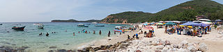
Español: Se encuentra dentro del Parque Nacional Mochima. Es una playa de aguas cristalinas y de verdes tonalidades, arena blanca y fina granulación. Ofrece servicios de restaurantes, sanitarios, alquiler de toldos, paseos en bote. También se puede acampar previa autorización de INPARQUES. Mochima. Sucre. Venezuela |
| Date | |
| Source | Own work |
| Author | Rjcastillo |
| Camera location | | View this and other nearby images on: OpenStreetMap |
|---|
Licensing
I, the copyright holder of this work, hereby publish it under the following license:
This file is licensed under the Creative Commons Attribution-Share Alike 3.0 Unported license.
- You are free:
- to share – to copy, distribute and transmit the work
- to remix – to adapt the work
- Under the following conditions:
- attribution – You must give appropriate credit, provide a link to the license, and indicate if changes were made. You may do so in any reasonable manner, but not in any way that suggests the licensor endorses you or your use.
- share alike – If you remix, transform, or build upon the material, you must distribute your contributions under the same or compatible license as the original.
This image has been assessed using the Quality image guidelines and is considered a Quality image.
|
File history
Click on a date/time to view the file as it appeared at that time.
| Date/Time | Thumbnail | Dimensions | User | Comment | |
|---|---|---|---|---|---|
| current | 02:55, 17 September 2013 | 7,413 × 1,745 (8.02 MB) | Rjcastillo | tilt, dust spot |
File usage
The following page uses this file: