
File:October 2012 - Overall Excellence in Smart Growth 2012- Lancaster, CA, The BLVD Transformation (8634270433).jpg

Original file (5,616 × 3,744 pixels, file size: 12.78 MB, MIME type: image/jpeg)
Summary
| Description |
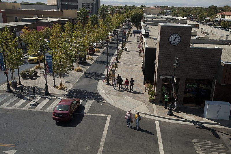
The redesign of Lancaster Boulevard helped transform downtown Lancaster into a thriving residential and commercial district through investments in new streetscape design, public facilities, affordable homes, and local businesses. Dubbed “The BLVD Transformation,” this comprehensive effort engaged residents and businesses to revitalize the formerly dilapidated downtown and make it a distinctive destination. Completed after just eight months of construction, The BLVD demonstrates how redesigning a corridor guided by a strategic vision can spark new life in a community. Photo courtesy of EPA. www.epa.gov/smartgrowth/awards/sg_awards_publication_2012... |
| Date | |
| Source | October 2012 - Overall Excellence in Smart Growth 2012: Lancaster, CA, The BLVD Transformation |
| Author | USEPA Environmental-Protection-Agency |
| Camera location | | View this and other nearby images on: OpenStreetMap |
|---|
.jpg¶ms=034.697907_N_-118.142037_E_globe:Earth_type:camera_source:Flickr_&language=en)
Licensing
This image (or other media) is a work of an Environmental Protection Agency employee, taken or made as part of that person's official duties. As works of the U.S. federal government, all EPA images are in the public domain.
|
||
| This image was originally posted to Flickr by usepagov at https://flickr.com/photos/24400159@N05/8634270433. It was reviewed on 1 October 2016 by FlickreviewR and was confirmed to be licensed under the terms of the United States Government Work. |
File history
Click on a date/time to view the file as it appeared at that time.
| Date/Time | Thumbnail | Dimensions | User | Comment | |
|---|---|---|---|---|---|
| current | 05:50, 1 October 2016 | | 5,616 × 3,744 (12.78 MB) | Vanished Account Byeznhpyxeuztibuo | Transferred from Flickr via Flickr2Commons |
File usage
The following page uses this file:
.jpg)