
File:Namche Bazaar Nepal.jpg

Size of this preview: 450 × 600 pixels. Other resolutions: 180 × 240 pixels | 2,448 × 3,264 pixels.
Original file (2,448 × 3,264 pixels, file size: 2.64 MB, MIME type: image/jpeg)
Summary
| Description |
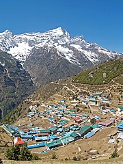
English: Namche Bazaar village located at 3,440 metres (11,286 ft) above the sea level in Khumbu region, northeastern Nepal. The Kongde Ri peak with its 6,187 m (20,299 ft) can be seen in the background.
Français : Le village de Namche Bazar, situé à 3 440 mètres au dessus du niveau de la mer, dans la région de Khumbu (Nord Népal). En arrière plan, on peut voir le Kongde Ri, culminant à 6 187 m. |
| Date | |
| Source |
https://www.flickr.com/photos/shicks/2515225403/
|
| Author | stevehicks |
| Camera location | | View this and other nearby images on: OpenStreetMap |
|---|
Licensing
| This image was originally posted to Flickr by stevehicks at https://www.flickr.com/photos/46052482@N00/2515225403. It was reviewed on 18 May 2011 by FlickreviewR and was confirmed to be licensed under the terms of the cc-by-2.0. |
This file is licensed under the Creative Commons Attribution 2.0 Generic license.
- You are free:
- to share – to copy, distribute and transmit the work
- to remix – to adapt the work
- Under the following conditions:
- attribution – You must give appropriate credit, provide a link to the license, and indicate if changes were made. You may do so in any reasonable manner, but not in any way that suggests the licensor endorses you or your use.
| Annotations | This image is annotated: View the annotations at Commons |

|
This image has been assessed under the valued image criteria and is considered the most valued image on Commons within the scope: Namche Bazaar, Nepal. You can see its nomination here. |
File history
Click on a date/time to view the file as it appeared at that time.
| Date/Time | Thumbnail | Dimensions | User | Comment | |
|---|---|---|---|---|---|
| current | 10:53, 18 May 2011 | | 2,448 × 3,264 (2.64 MB) | MrPanyGoff |
File usage
The following page uses this file: