
File:Mallorca Schönste Strände Cala S Amarador (190269447).jpeg

Size of this preview: 800 × 533 pixels. Other resolutions: 320 × 213 pixels | 2,048 × 1,365 pixels.
Original file (2,048 × 1,365 pixels, file size: 1.03 MB, MIME type: image/jpeg)
Summary
| Mallorca Schönste Strände Cala S Amarador | |
|---|---|
| Photographer | |
| Title |
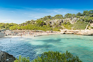
Mallorca Schönste Strände Cala S Amarador |
| Description |
500px provided description: Mallorca Schönste Strände Cala S Amarador [#landscape ,#beach ,#travel ,#island ,#summer ,#nikon ,#mallorca ,#party ,#holiday ,#sommer ,#natur ,#es ,#strand ,#urlaub ,#spanien ,#insel ,#arenal ,#reise ,#ferien ,#cala ,#geotagged ,#wanderlust ,#arta ,#platja ,#malle ,#balearen ,#strandurlaub ,#str?nde ,#illesbalears ,#sch?nste ,#santany? ,#allgemein ,#travelblogger ,#l?nderst?dte ,#sarenal ,#samarador ,#sch?nstestr?nde ,#calasamarador] |
| Date | 16 October 2016, 16:59:31 (UTC) |
| Source | Imported from 500px (archived version) by the Archive Team. (detail page) |
| Permission (Reusing this file) |
This file is licensed under the Creative Commons Attribution 3.0 Unported license.
|
| Camera location | | View this and other nearby images on: OpenStreetMap |
|---|
.jpeg¶ms=039.350928_N_0003.186828_E_globe:Earth_type:camera__&language=en)
File history
Click on a date/time to view the file as it appeared at that time.
| Date/Time | Thumbnail | Dimensions | User | Comment | |
|---|---|---|---|---|---|
| current | 21:21, 10 August 2018 | | 2,048 × 1,365 (1.03 MB) | Rodrigo.Argenton | Photo Mallorca Schönste Strände Cala S Amarador imported from 500px with import-500px |
File usage
The following page uses this file:
.jpeg)