
File:Jerusalem-2013-Temple Mount-Dome of the Rock & Chain 02.jpg

Size of this preview: 426 × 600 pixels. Other resolutions: 170 × 240 pixels | 5,000 × 7,039 pixels.
Original file (5,000 × 7,039 pixels, file size: 22.28 MB, MIME type: image/jpeg)
Summary
| Description |
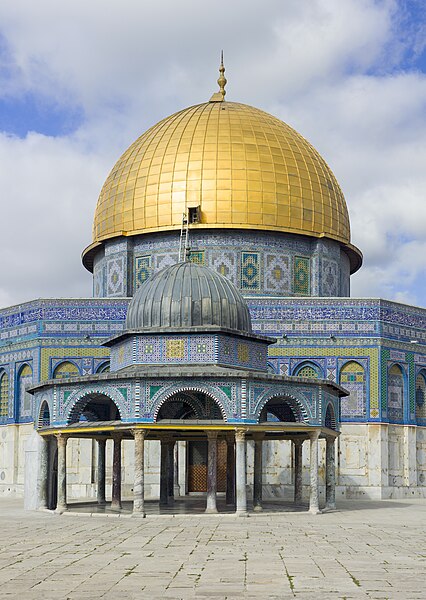
العربية: قِبَّةُ السلسلة ومن خلفها مسجد قِبَّةُ الصخرة، الواقعة ضمن الحرم القدسي الشريف في بلدة القدس القديمة. أُنشأت قِبَّةُ السلسلة في العهد الأُموي (حوالي سنة 685 م) واتُّخذت نموذجًا لدى بناء قبَّة الصخرة (حوالي سنة 691م).
English: The Dome of the Chain (Arabic: قبة السلسلة, Qubbat al-Silsila) in front of The Dome of the Rock (Arabic: مسجد قبة الصخرة, Hebrew: כיפת הסלע), on the Temple Mount in the Old City of Jerusalem. The Dome of the Chain was constructed during the Umayyad Caliphate (c. 685 AD) and served as a model for the building of the Dome of the Rock (c. 691 AD).
Italiano: La cupola della catena (arabo: قبة السلسلة, Qubbat al-Silsila) di fronte alla Cupola della roccia (arabo: مسجد قبة الصخرة, ebreo: כיפת הסלע), sul Monte del Tempio nella Città Vecchia di Gerusalemme. |
| Date | |
| Source | Own work |
| Author | Godot13 |
| Attribution (required by the license) | Andrew Shiva / Wikipedia / |
| Camera location | | View this and other nearby images on: OpenStreetMap |
|---|
|
This image was selected as picture of the day on Wikimedia Commons for 8 May 2014. It was captioned as follows: English: The Dome of the Chain (Arabic: قبة السلسلة, Qubbat al-Silsila) in front of The Dome of the Rock (Arabic: مسجد قبة الصخرة, Hebrew: כיפת הסלע), on the Temple Mount in the Old City of Jerusalem. Other languages:
Bosanski: Kupola na lancima (arapski: قبة السلسلة, Kubat el-silsila) ispred Kupole nad miradžskom stijenom (arapski: مسجد قبة الصخرة, hebrejski: כיפת הסלע), na Brdu hrama u Starom gradu u Jerusalemu. Čeština: Řetězový dóm (arabsky: قبة السلسلة, Qubbat al-Silsila) před Skalním dómem (arabsky: مسجد قبة الصخرة, hebrejsky: כיפת הסלע) na Chrámové hoře v Jeruzalémském Starém Městě. English: The Dome of the Chain (Arabic: قبة السلسلة, Qubbat al-Silsila) in front of The Dome of the Rock (Arabic: مسجد قبة الصخرة, Hebrew: כיפת הסלע), on the Temple Mount in the Old City of Jerusalem. Français : Le Dôme du Temple (en arabe : قبة السلسلة, Qubbat al-Silsila), situé en face du Dôme du Rocher (en arabe : مسجد قبة الصخرة, en hébreux : כיפת הסלע), sur le Mont du Temple, dans la Vieille ville de Jérusalem. Italiano: La cupola della catena (arabo: قبة السلسلة, Qubbat al-Silsila) di fronte alla Cupola della roccia (arabo: مسجد قبة الصخرة, ebreo: כיפת הסלע), sul Monte del Tempio nella Città Vecchia di Gerusalemme. Português: O Domo da Cadeia (Árabe: قبة السلسلة, Qubbat al-Silsila) em frente ao Domo da Rocha (Árabe: مسجد قبة الصخرة, Hebreu: כיפת הסלע), no Monte do Templo na Cidade Velha de Jerusalém. 中文: 耶路撒冷圆顶清真寺。 |
Licensing
I, the copyright holder of this work, hereby publish it under the following license:
This file is licensed under the Creative Commons Attribution-Share Alike 4.0 International license.
- You are free:
- to share – to copy, distribute and transmit the work
- to remix – to adapt the work
- Under the following conditions:
- attribution – You must give appropriate credit, provide a link to the license, and indicate if changes were made. You may do so in any reasonable manner, but not in any way that suggests the licensor endorses you or your use.
- share alike – If you remix, transform, or build upon the material, you must distribute your contributions under the same or compatible license as the original.

|
The copyright holder of this file, Andrew Shiva, allows anyone to use it for any purpose, provided that the copyright holder is properly attributed. Redistribution, derivative work, commercial use, and all other use is permitted. |
Attribution:
Use or reproduction of this image outside of Wikipedia must give the original photographer (Andrew Shiva) credit. Although not required, it would be appreciated if a message was left here indicating where this image was being used.
|
File history
Click on a date/time to view the file as it appeared at that time.
| Date/Time | Thumbnail | Dimensions | User | Comment | |
|---|---|---|---|---|---|
| current | 02:02, 7 October 2013 | | 5,000 × 7,039 (22.28 MB) | Godot13 | reworked from raw file for original colors |
File usage
The following page uses this file: