
File:Japan regions map.png

Size of this preview: 486 × 600 pixels. Other resolutions: 194 × 240 pixels | 2,430 × 3,000 pixels.
Original file (2,430 × 3,000 pixels, file size: 1.13 MB, MIME type: image/png)

|
This map of asia image could be re-created using vector graphics as an SVG file. This has several advantages; see Commons:Media for cleanup for more information. If an SVG form of this image is available, please upload it and afterwards replace this template with
{{vector version available|new image name}}.
It is recommended to name the SVG file “Japan regions map.svg”—then the template Vector version available (or Vva) does not need the new image name parameter. |
Summary
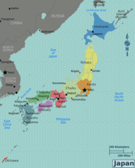
| Description | Japan regions map for use on Wikivoyage, English version |
| Date | |
| Source | Own work based on the blank map of Japan by Erida539, map of Primorsky krai by Stefan Ertmann, map of North Korea by Burmesedays, and map of South Korea |
| Author | Peter Fitzgerald |
| Other versions |
.png)
.png)
.png)
.png)
.png)
.png)
.png)
Licensing

|
Permission is granted to copy, distribute and/or modify this document under the terms of the GNU Free Documentation License, Version 1.2 or any later version published by the Free Software Foundation; with no Invariant Sections, no Front-Cover Texts, and no Back-Cover Texts. A copy of the license is included in the section entitled GNU Free Documentation License. |
This file is licensed under the Creative Commons Attribution-Share Alike 4.0 International, 3.0 Unported, 2.5 Generic, 2.0 Generic and 1.0 Generic license.
- You are free:
- to share – to copy, distribute and transmit the work
- to remix – to adapt the work
- Under the following conditions:
- attribution – You must give appropriate credit, provide a link to the license, and indicate if changes were made. You may do so in any reasonable manner, but not in any way that suggests the licensor endorses you or your use.
- share alike – If you remix, transform, or build upon the material, you must distribute your contributions under the same or compatible license as the original.
Original upload log
| This file was imported from Wikivoyage WTS. |
The original description page was here. All following user names refer to wts.wikivoyage-old.
- 2009-12-26 22:29 (WT-shared) Peterfitzgerald archive copy at the Wayback Machine 2437×3008 (1166305 bytes) {{Imagecredit|credit=Peter Fitzgerald [[:wmc:User:Erida539]], [[:wmc:User:NordNordWest]], Stefan Ertmann, [[User:Burmesedays]]|captureDate=2 (Import from wikitravel.org/shared)
- 2009-12-28 16:31 (WT-shared) Peterfitzgerald archive copy at the Wayback Machine 2437×3008 (1185144 bytes) moving Kurils back to Russia (thank you, source file...) (Import from wikitravel.org/shared)
- 2011-10-22 22:40 (WT-shared) Joelf[dead link] 2430×3000 (1182395 bytes) Phillipine Sea -> Philippine Sea (Import from wikitravel.org/shared)
File history
Click on a date/time to view the file as it appeared at that time.
| Date/Time | Thumbnail | Dimensions | User | Comment | |
|---|---|---|---|---|---|
| current | 22:23, 24 November 2012 | | 2,430 × 3,000 (1.13 MB) | OgreBot | (BOT): Reverting to most recent version before archival |
File usage
The following page uses this file: