File:Indian River Inlet Bridge DE5.jpg
Original file (5,472 × 3,900 pixels, file size: 10.35 MB, MIME type: image/jpeg)
This file is from Wikimedia Commons and may be used by other projects. The description on its file description page there is shown below.
Summary
DescriptionIndian River Inlet Bridge DE5.jpg |
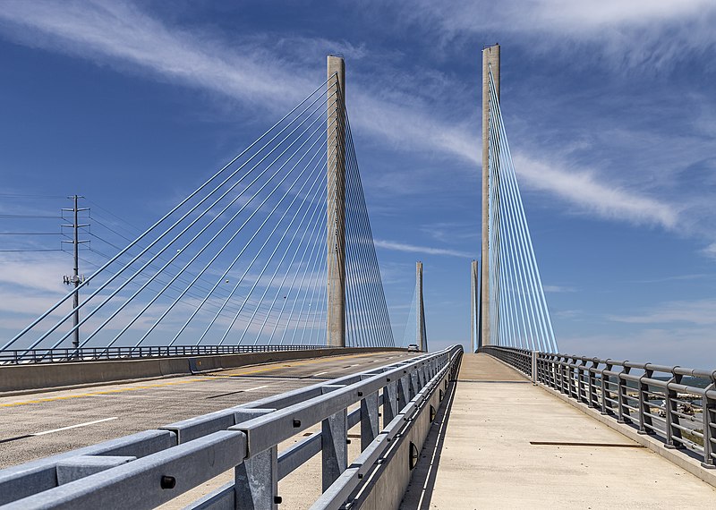
English: The Indian River Inlet Bridge, Delaware, USA
Français : Le pont d'Indian River Inlet dans le Delaware, États-Unis |
Date | |
Source | Own work |
Author | Acroterion |
Camera location | 38° 36′ 20.02″ N, 75° 03′ 47.21″ W | View this and other nearby images on: OpenStreetMap | 38.605560; -75.063113 |
---|
Licensing
Permission is granted to copy, distribute and/or modify this document under the terms of the GNU Free Documentation License, Version 1.2 or any later version published by the Free Software Foundation; with no Invariant Sections, no Front-Cover Texts, and no Back-Cover Texts. A copy of the license is included in the section entitled GNU Free Documentation License.http://www.gnu.org/copyleft/fdl.htmlGFDLGNU Free Documentation Licensetruetrue |
- You are free:
- to share – to copy, distribute and transmit the work
- to remix – to adapt the work
- Under the following conditions:
- attribution – You must give appropriate credit, provide a link to the license, and indicate if changes were made. You may do so in any reasonable manner, but not in any way that suggests the licensor endorses you or your use.
- share alike – If you remix, transform, or build upon the material, you must distribute your contributions under the same or compatible license as the original.
This image has been assessed using the Quality image guidelines and is considered a Quality image.
العربية ∙ جازايرية ∙ беларуская ∙ беларуская (тарашкевіца) ∙ български ∙ বাংলা ∙ català ∙ čeština ∙ Cymraeg ∙ Deutsch ∙ Schweizer Hochdeutsch ∙ Zazaki ∙ Ελληνικά ∙ English ∙ Esperanto ∙ español ∙ eesti ∙ euskara ∙ فارسی ∙ suomi ∙ français ∙ galego ∙ עברית ∙ हिन्दी ∙ hrvatski ∙ magyar ∙ հայերեն ∙ Bahasa Indonesia ∙ italiano ∙ 日本語 ∙ Jawa ∙ ქართული ∙ 한국어 ∙ kurdî ∙ Lëtzebuergesch ∙ lietuvių ∙ македонски ∙ മലയാളം ∙ मराठी ∙ Bahasa Melayu ∙ Nederlands ∙ Norfuk / Pitkern ∙ polski ∙ português ∙ português do Brasil ∙ rumantsch ∙ română ∙ русский ∙ sicilianu ∙ slovenčina ∙ slovenščina ∙ shqip ∙ српски / srpski ∙ svenska ∙ தமிழ் ∙ తెలుగు ∙ ไทย ∙ Tagalog ∙ Türkçe ∙ toki pona ∙ українська ∙ vèneto ∙ Tiếng Việt ∙ 中文 ∙ 中文(简体) ∙ 中文(繁體) ∙ +/− |
Items portrayed in this file
depicts
21 May 2019
38°36'20.016"N, 75°3'47.207"W
0.001 second
35 millimetre
100
File history
Click on a date/time to view the file as it appeared at that time.
Date/Time | Thumbnail | Dimensions | User | Comment | |
---|---|---|---|---|---|
current | 02:41, 25 May 2019 | 5,472 × 3,900 (10.35 MB) | Acroterion | {{Information |description ={{en|1=The Indian River Inlet Bridge, Delaware, USa}} |date =2019-05-21 |source ={{own}} |author =Acroterion }} Category:Indian River Inlet Bridge |
File usage
The following page uses this file:
Metadata
This file contains additional information, probably added from the digital camera or scanner used to create or digitize it.
If the file has been modified from its original state, some details may not fully reflect the modified file.
Camera manufacturer | Canon |
---|---|
Camera model | Canon EOS 6D |
Exposure time | 1/1,000 sec (0.001) |
F Number | f/8 |
ISO speed rating | 100 |
Date and time of data generation | 17:41, 21 May 2019 |
Lens focal length | 35 mm |
Latitude | 38° 36′ 20.02″ N |
Longitude | 75° 3′ 47.21″ W |
Altitude | 6.9 meters above sea level |
Orientation | Normal |
Horizontal resolution | 300 dpi |
Vertical resolution | 300 dpi |
Software used | Adobe Photoshop CC 2019 (Windows) |
File change date and time | 22:39, 24 May 2019 |
Exposure Program | Aperture priority |
Exif version | 2.3 |
Date and time of digitizing | 17:41, 21 May 2019 |
APEX shutter speed | 9.965784 |
APEX aperture | 6 |
APEX exposure bias | -1 |
Maximum land aperture | 4 APEX (f/4) |
Metering mode | Pattern |
Flash | Flash did not fire, compulsory flash suppression |
DateTime subseconds | 29 |
DateTimeOriginal subseconds | 29 |
DateTimeDigitized subseconds | 29 |
Color space | Uncalibrated |
Focal plane X resolution | 1,520 |
Focal plane Y resolution | 1,520 |
Focal plane resolution unit | 3 |
Custom image processing | Normal process |
Exposure mode | Auto exposure |
White balance | Auto white balance |
Scene capture type | Standard |
GPS time (atomic clock) | 17:38 |
Satellites used for measurement | 12 |
Receiver status | Measurement in progress |
Measurement mode | 3-dimensional measurement |
Measurement precision | Poor (4.3) |
Geodetic survey data used | WGS-84 |
GPS date | 21 May 2019 |
GPS tag version | 0.0.3.2 |
Serial number of camera | 122025005461 |
Lens used | EF24-105mm f/4L IS USM |
Rating (out of 5) | 0 |
Date metadata was last modified | 18:39, 24 May 2019 |
Unique ID of original document | 22E33223C967EB922498A3CC9971A08D |