
File:Holmen (37848359046).jpg

Size of this preview: 800 × 533 pixels. Other resolutions: 320 × 213 pixels | 5,520 × 3,680 pixels.
Original file (5,520 × 3,680 pixels, file size: 5.94 MB, MIME type: image/jpeg)
Summary
| Description |
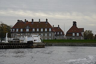
English: Langelinie (English: Long Line) is a pier, promenade and park in central Copenhagen, Denmark, and home of The Little Mermaid statue. The area has for centuries been a popular destination for excursions and strolls in Copenhagen. Most cruise ships arriving in Copenhagen also berth at Langelinie Pier.
The Langelinie Park (Danish: Langelinieparken) stretches from Esplanaden in the south to Langelinie Marina and the base of the Langelinie Pier in the north. Formally, it includes Kastellet although this site is generally referred to under its own name. The park contains numerous monuments, buildings, a marina, statues and a playground. Among these are the Gefion Fountain, the Ivar Huitfeldt Column and The Little Mermaid [Wikipedia.org] |
| Date | |
| Source | Langelinie |
| Author | Jorge Láscar from Melbourne, Australia |
| Camera location | | View this and other nearby images on: OpenStreetMap |
|---|
.jpg¶ms=055.691005_N_0012.605863_E_globe:Earth_type:camera_source:Flickr_&language=en)
Licensing
This file is licensed under the Creative Commons Attribution 2.0 Generic license.
- You are free:
- to share – to copy, distribute and transmit the work
- to remix – to adapt the work
- Under the following conditions:
- attribution – You must give appropriate credit, provide a link to the license, and indicate if changes were made. You may do so in any reasonable manner, but not in any way that suggests the licensor endorses you or your use.
| This image was originally posted to Flickr by Jorge Lascar at https://flickr.com/photos/8721758@N06/37848359046 (archive). It was reviewed on 8 February 2018 by FlickreviewR 2 and was confirmed to be licensed under the terms of the cc-by-2.0. |
File history
Click on a date/time to view the file as it appeared at that time.
| Date/Time | Thumbnail | Dimensions | User | Comment | |
|---|---|---|---|---|---|
| current | 09:28, 8 February 2018 | | 5,520 × 3,680 (5.94 MB) | Thesupermat2 | Transferred from Flickr via Flickr2Commons |
File usage
The following page uses this file:
.jpg)