
File:Guadalupe Peak from Bowl Trail.JPG

Size of this preview: 800 × 254 pixels. Other resolutions: 320 × 102 pixels | 7,913 × 2,515 pixels.
Original file (7,913 × 2,515 pixels, file size: 13.66 MB, MIME type: image/jpeg)
Summary
| Description |
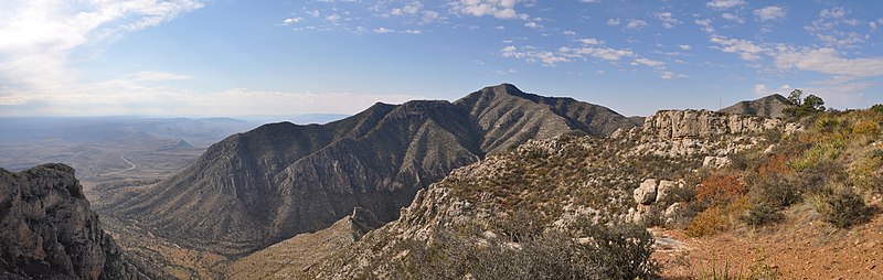
English: Guadalupe Peak and Pine Spring Canyon viewed from the Bowl Trail between its intersection with the Tejas Trail and Hunter Peak in Guadalupe Mountains National Park, Texas.
Shumard Peak is visible at right and the Delaware Mountains and US route 62/180 are visible at left in background. Center of image is looking approximately southwest. |
| Date | |
| Source | Own work |
| Author | Fredlyfish4 |
| Camera location | | View this and other nearby images on: OpenStreetMap |
|---|
| Annotations | This image is annotated: View the annotations at Commons |
Licensing
I, the copyright holder of this work, hereby publish it under the following license:
This file is licensed under the Creative Commons Attribution-Share Alike 3.0 Unported license.
- You are free:
- to share – to copy, distribute and transmit the work
- to remix – to adapt the work
- Under the following conditions:
- attribution – You must give appropriate credit, provide a link to the license, and indicate if changes were made. You may do so in any reasonable manner, but not in any way that suggests the licensor endorses you or your use.
- share alike – If you remix, transform, or build upon the material, you must distribute your contributions under the same or compatible license as the original.
| File created by Fredlyfish4 | |
| Permission is granted for use under CC BY-SA 4.0 (or a similar license) for this file created by the author.
Please let the author know if you use this work outside of Wikimedia projects by sending an email to
|
This image has been assessed using the Quality image guidelines and is considered a Quality image.
|
File history
Click on a date/time to view the file as it appeared at that time.
| Date/Time | Thumbnail | Dimensions | User | Comment | |
|---|---|---|---|---|---|
| current | 17:25, 8 November 2012 | 7,913 × 2,515 (13.66 MB) | Fredlyfish4 | User created page with UploadWizard |
File usage
The following page uses this file: