
File:General view of Basseterre, St. Kitts from Ship (8642159070).jpg

Original file (1,250 × 756 pixels, file size: 599 KB, MIME type: image/jpeg)
Summary
| Description |
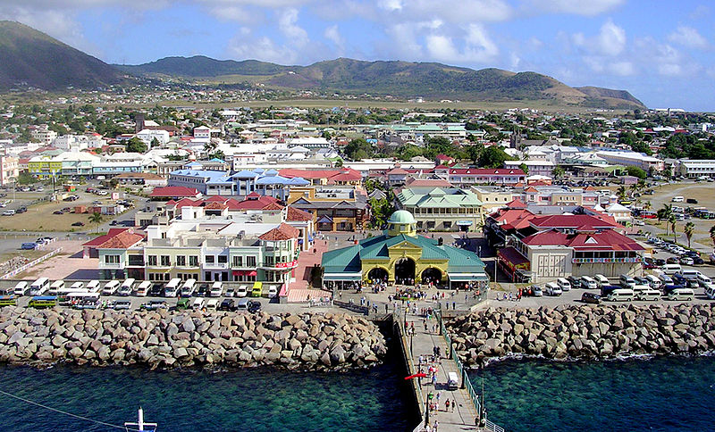
I took this general view of Basseterre, St. Kitts from the top deck of our ship. It shows most of my walk in the city. I went through the visitor center (green roof) and straight through the "Port Zante" district of tourist shops into the city proper. My main destlnation was Independence Square (Pall Mall Square before independence from Britain), the large green area. The Catholic cathedral is at the right end of the square. I walked to the Anglican church at the left, then in the direction of the ship to The Circus, with the white dome of the National Museum (formerly the Customs House) above the blue roof building. I walked to the left beyond the photo to the terminal and market, then back to the area of tourist shops and the ship. The airport is the open field beyond the city. Basseterre has only 15,000 people. |
| Date | |
| Source | St. Kitts - Basseterre from Ship |
| Author | Roger W from Sarasota, Florida, U.S.A. |
| Camera location | | View this and other nearby images on: OpenStreetMap |
|---|
.jpg¶ms=017.293609_N_-062.731075_E_globe:Earth_type:camera_source:Flickr_&language=en)
Licensing
- You are free:
- to share – to copy, distribute and transmit the work
- to remix – to adapt the work
- Under the following conditions:
- attribution – You must give appropriate credit, provide a link to the license, and indicate if changes were made. You may do so in any reasonable manner, but not in any way that suggests the licensor endorses you or your use.
- share alike – If you remix, transform, or build upon the material, you must distribute your contributions under the same or compatible license as the original.
| This image was originally posted to Flickr by roger4336 at https://flickr.com/photos/24736216@N07/8642159070. It was reviewed on 29 January 2016 by FlickreviewR and was confirmed to be licensed under the terms of the cc-by-sa-2.0. |
File history
Click on a date/time to view the file as it appeared at that time.
| Date/Time | Thumbnail | Dimensions | User | Comment | |
|---|---|---|---|---|---|
| current | 17:31, 29 January 2016 | | 1,250 × 756 (599 KB) | Atlasowa | Transferred from Flickr via Flickr2Commons |
File usage
The following page uses this file:
.jpg)