
File:Friesenbergsee und Friesenberghaus, Zillertaler Alpen 07.jpg

Size of this preview: 800 × 252 pixels. Other resolutions: 320 × 101 pixels | 9,396 × 2,958 pixels.
Original file (9,396 × 2,958 pixels, file size: 22.66 MB, MIME type: image/jpeg)
| Description |
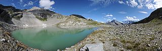
Deutsch: Panorama am Friesenbergsee am Nachmittag um 16:00 Uhr. Das Friesenberghaus ist eine Schutzhütte des Deutschen Alpenvereins (DAV) in den Zillertaler Alpen auf einer Höhe von 2498 Metern im österreichischen Bundesland Tirol und gleichzeitig ein Etappenziel des Berliner Höhenweges, der unter anderem auch zur ca. 2 Stunden entfernten Olpererhütte führt.
English: Panoramic view of the friezenberg lake at 4:00 p.m. The Friesenberghaus is a refuge of the German Alpine Association (DAV) in the Zillertal Alps at an altitude of 2498 meters in the Austrian province of Tyrol and also a milestone of the Berlin High Trail, which leads among other things, to the Olpererhütte, about 2 hours away.
Français : Vue panoramique sur le lac friezenberg à 4h00 de l'après-midi. La Friesenberghaus est un refuge de l'association alpine allemande (Deutscher Alpenverein, ou DAV). Ce lac se trouve à une altitude de 2498 mètres dans les alpes de Zillertal (Tyrol, Autriche). Il est une attraction du Berlin High Trail qui mène, entre autres, à l'Olpererhütte, à deux heures de marche.
|
||
| Date | |||
| Source | Own work | ||
| Author |
|
||
| Permission (Reusing this file) |
I, the copyright holder of this work, hereby publish it under the following licenses:
This file is licensed under the Creative Commons Attribution-Share Alike 3.0 Austria license.
 You may select the license of your choice. |


| Camera location | | View this and other nearby images on: OpenStreetMap |
|---|
| Annotations | This image is annotated: View the annotations at Commons |
This image has been assessed using the Quality image guidelines and is considered a Quality image.
|
File history
Click on a date/time to view the file as it appeared at that time.
| Date/Time | Thumbnail | Dimensions | User | Comment | |
|---|---|---|---|---|---|
| current | 22:46, 6 February 2013 | 9,396 × 2,958 (22.66 MB) | Böhringer | Linsenfleck enfernt |
File usage
The following page uses this file: