
File:Fort McHenry National Monument, Baltimore, Maryland.jpg

Original file (4,000 × 3,000 pixels, file size: 3.73 MB, MIME type: image/jpeg)
Summary
| Description |
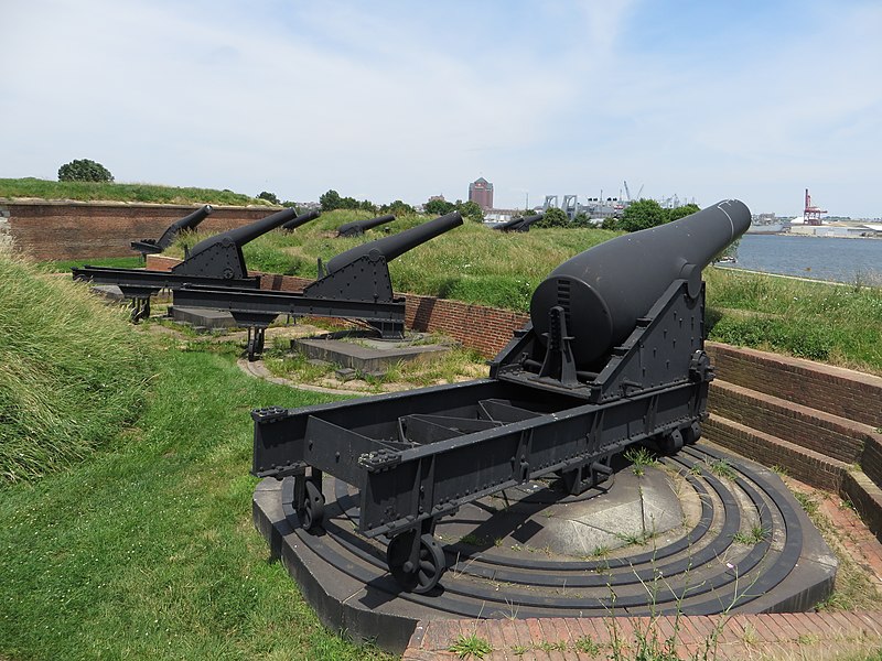
English: Fort McHenry, in Baltimore, Maryland, is a coastal star-shaped fort best known for its role in the War of 1812, when it successfully defended Baltimore Harbor from an attack by the British navy in Chesapeake Bay September 13–14, 1814. It was during the bombardment of the fort that Francis Scott Key was inspired to write "The Star-Spangled Banner," the poem that would eventually be set to the tune of "To Anacreon in Heaven" and become the national anthem of the United States.
Fort McHenry was built on Whetstone Point (today's residential and industrial area of Locust Point) peninsula, which juts into the opening of Baltimore Harbor between the Basin (today's Inner Harbor) and Northwest branch on the north side and the Middle and Ferry (now Southern) branches of the Patapsco River on the south side. The Frenchman Jean Foncin designed the fort in 1798, and it was built between 1798 and 1800. The new fort's purpose was to improve the defenses of the increasingly important Port of Baltimore from future enemy attacks. The new fort was constructed in the form of a five-pointed star surrounded by a dry moat — a deep, broad trench. The moat would serve as a shelter from which infantry might defend the fort from a land attack. In case of such an attack on this first line of defense, each point, or bastion could provide a crossfire of cannon and small arms fire. Fort McHenry was named after early American statesman James McHenry (16 November 1753 – 3 May 1816), a Scots-Irish immigrant and surgeon-soldier. He was a delegate to the Continental Congress from Maryland and a signer of the United States Constitution. Afterwards, he was appointed United States Secretary of War (1796–1800), serving under presidents Presidents George Washington and John Adams. Beginning at 6:00 a.m. on 13 September 1814, British warships under the command of Vice Admiral Alexander Cochrane continuously bombarded Fort McHenry for 25 hours. The American defenders had 18, 24, and 38-pound (8.2, 11, and 17 kg) cannons with a maximum range of 1.5 miles (2.4 km). The British guns had a range of 2 miles (3 km), and their rockets had a 1.75-mile (2.8 km) range, but neither guns nor rockets were accurate. The British ships were unable to pass Fort McHenry and penetrate Baltimore Harbor because of its defenses, including a chain of 22 sunken ships, and the American cannons. They were, however, able to come close enough at maximum range to fire rockets and mortars at the fort. Due to the poor accuracy of the British weapons at maximum range, and the limited range of the American guns, very little damage was done on either side before the British ceased their attack on the morning of 14 September due to a lack of ammunition. Thus the naval part of the British invasion of Baltimore had been repulsed. Only one British warship, a bomb vessel, received a direct hit from the fort's return fire, which wounded one crewman. The Americans were under the command of Major George Armistead. They did suffer casualties, amounting to four killed and 24 wounded, including one African-American soldier and a woman who was cut in half by a bomb as she carried supplies to the troops. At one point during the bombardment, a bomb crashed through the fort's powder magazine. Fortunately for the defenders, either the fuse was extinguished by the rain or the bomb was merely a dud. Francis Scott Key, a Washington lawyer who had come to Baltimore to negotiate the release of Dr. William Beanes, a civilian prisoner of war, witnessed the bombardment from a nearby truce ship. An oversized American flag had been sewn by Mary Pickersgill for $405.90 in anticipation of the British attack on the fort. When Key saw the flag emerge intact in the dawn of September 14, he was so moved that he began that morning to compose the poem "Defence of Fort M'Henry" which would later be renamed "The Star-Spangled Banner" and become the United States' national anthem. |
| Date | |
| Source | Flickr - https://www.flickr.com/photos/kenlund/14311517458 |
| Author | Ken Lund |
| Camera location | | View this and other nearby images on: OpenStreetMap |
|---|
Licensing
| This image was originally posted to Flickr by Ken Lund at https://flickr.com/photos/75683070@N00/14311517458. It was reviewed on 24 March 2017 by FlickreviewR and was confirmed to be licensed under the terms of the cc-by-sa-2.0. |
- You are free:
- to share – to copy, distribute and transmit the work
- to remix – to adapt the work
- Under the following conditions:
- attribution – You must give appropriate credit, provide a link to the license, and indicate if changes were made. You may do so in any reasonable manner, but not in any way that suggests the licensor endorses you or your use.
- share alike – If you remix, transform, or build upon the material, you must distribute your contributions under the same or compatible license as the original.
File history
Click on a date/time to view the file as it appeared at that time.
| Date/Time | Thumbnail | Dimensions | User | Comment | |
|---|---|---|---|---|---|
| current | 00:19, 24 March 2017 | | 4,000 × 3,000 (3.73 MB) | AndreCarrotflower | User created page with UploadWizard |
File usage
The following page uses this file: