File:Costa Victoria in Port Sultan Qaboos, Muscat, Oman 20120408 1.jpg
Original file (7,932 × 2,991 pixels, file size: 7.41 MB, MIME type: image/jpeg)
This file is from Wikimedia Commons and may be used by other projects. The description on its file description page there is shown below.
Summary
DescriptionCosta Victoria in Port Sultan Qaboos, Muscat, Oman 20120408 1.jpg |
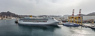
English: Costa Victoria and the surrounding Port Sultan Qaboos in Muscat, Oman as seen from another cruise ship |
Date | |
Source | Own work |
Author | DXR |
Camera location | 23° 37′ 44.33″ N, 58° 34′ 12.34″ E | View this and other nearby images on: OpenStreetMap | 23.628980; 58.570095 |
---|
Licensing
- You are free:
- to share – to copy, distribute and transmit the work
- to remix – to adapt the work
- Under the following conditions:
- attribution – You must give appropriate credit, provide a link to the license, and indicate if changes were made. You may do so in any reasonable manner, but not in any way that suggests the licensor endorses you or your use.
- share alike – If you remix, transform, or build upon the material, you must distribute your contributions under the same or compatible license as the original.
This image has been assessed using the Quality image guidelines and is considered a Quality image.
العربية ∙ جازايرية ∙ беларуская ∙ беларуская (тарашкевіца) ∙ български ∙ বাংলা ∙ català ∙ čeština ∙ Cymraeg ∙ Deutsch ∙ Schweizer Hochdeutsch ∙ Zazaki ∙ Ελληνικά ∙ English ∙ Esperanto ∙ español ∙ eesti ∙ euskara ∙ فارسی ∙ suomi ∙ français ∙ galego ∙ עברית ∙ हिन्दी ∙ hrvatski ∙ magyar ∙ հայերեն ∙ Bahasa Indonesia ∙ italiano ∙ 日本語 ∙ Jawa ∙ ქართული ∙ 한국어 ∙ kurdî ∙ Lëtzebuergesch ∙ lietuvių ∙ македонски ∙ മലയാളം ∙ मराठी ∙ Bahasa Melayu ∙ Nederlands ∙ Norfuk / Pitkern ∙ polski ∙ português ∙ português do Brasil ∙ rumantsch ∙ română ∙ русский ∙ sicilianu ∙ slovenčina ∙ slovenščina ∙ shqip ∙ српски / srpski ∙ svenska ∙ தமிழ் ∙ తెలుగు ∙ ไทย ∙ Tagalog ∙ Türkçe ∙ toki pona ∙ українська ∙ vèneto ∙ Tiếng Việt ∙ 中文 ∙ 中文(简体) ∙ 中文(繁體) ∙ +/− |
Items portrayed in this file
depicts
8 April 2012
23°37'44.328"N, 58°34'12.342"E
image/jpeg
00f7c3b5199a45979bcb8b5600f165e5f6b7a88a
7,772,279 byte
2,991 pixel
7,932 pixel
File history
Click on a date/time to view the file as it appeared at that time.
Date/Time | Thumbnail | Dimensions | User | Comment | |
---|---|---|---|---|---|
current | 10:42, 13 July 2014 | 7,932 × 2,991 (7.41 MB) | DXR | User created page with UploadWizard |
File usage
The following page uses this file:
Metadata
This file contains additional information, probably added from the digital camera or scanner used to create or digitize it.
If the file has been modified from its original state, some details may not fully reflect the modified file.
Author | Daniel Vorndran |
---|---|
Date and time of data generation | 12:01, 8 April 2012 |
Latitude | 23° 37′ 44.33″ N |
Longitude | 58° 34′ 12.34″ E |
Horizontal resolution | 240 dpi |
Vertical resolution | 240 dpi |
Software used | Adobe Photoshop Lightroom 5.4 (Windows) |
File change date and time | 12:18, 13 July 2014 |
Exif version | 2.3 |
Date and time of digitizing | 12:01, 8 April 2012 |
DateTimeOriginal subseconds | 70 |
DateTimeDigitized subseconds | 70 |
GPS tag version | 0.0.2.2 |
Date metadata was last modified | 14:18, 13 July 2014 |
Unique ID of original document | 501D18D4733A3B197F85DB527304CB66 |
Short title |
|
City shown | Muskat |
Province or state shown | Muscat Governorate |
Country shown | Oman |
Sublocation of city shown | Matrah |
IIM version | 4 |