
File:Bratislava - Reduta Casino Cafe Reduta.jpg

Size of this preview: 800 × 533 pixels. Other resolutions: 320 × 213 pixels | 5,184 × 3,456 pixels.
Original file (5,184 × 3,456 pixels, file size: 8.76 MB, MIME type: image/jpeg)
Summary
| Description |
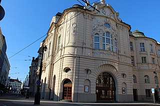
Staré Mesto. Medená Historicist building designed as entertainment hall and reunion hall. There have also been several clubs, such as Schlarafia, and Reduta Cinema for many years. Arch. Dezider Jakab and Marcel Komor 1913-19 On Medená, there is a casino, a café and restaurant. |
| Date | Taken on 5 August 2017, 17:52 |
| Source | Bratislava - Reduta: Casino Cafe Reduta |
| Author | Fred Romero from Paris, France |
| Camera location | | View this and other nearby images on: OpenStreetMap |
|---|
|
According to section 37 and 41 of the Slovak copyright law, Slovakia has freedom of panorama. Works permanently located at public places may be freely reproduced and such reproductions may be freely published and sold without the consent of the original author.
See COM:CRT/Slovakia#Freedom of panorama for more information.
|
Licensing
This file is licensed under the Creative Commons Attribution 2.0 Generic license.
- You are free:
- to share – to copy, distribute and transmit the work
- to remix – to adapt the work
- Under the following conditions:
- attribution – You must give appropriate credit, provide a link to the license, and indicate if changes were made. You may do so in any reasonable manner, but not in any way that suggests the licensor endorses you or your use.
| This image was originally posted to Flickr by corno.fulgur75 at https://flickr.com/photos/129231073@N06/38062763216 (archive). It was reviewed on 25 February 2019 by FlickreviewR 2 and was confirmed to be licensed under the terms of the cc-by-2.0. |
File history
Click on a date/time to view the file as it appeared at that time.
| Date/Time | Thumbnail | Dimensions | User | Comment | |
|---|---|---|---|---|---|
| current | 12:51, 25 February 2019 | | 5,184 × 3,456 (8.76 MB) | Villarreal9 | Transferred from Flickr via #flickr2commons |
File usage
The following page uses this file: