
File:Bakersfield aerial with Kern River.jpg

Size of this preview: 800 × 332 pixels. Other resolutions: 320 × 133 pixels | 2,637 × 1,093 pixels.
Original file (2,637 × 1,093 pixels, file size: 1.15 MB, MIME type: image/jpeg)
Summary
| Description |
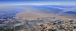
English: Aerial view of Bakersfield, California, and vicinity, showing the Kern River coming from the southern Sierra Nevadas |
| Date | |
| Source | Own work |
| Author | Dicklyon |
| Camera location | | View this and other nearby images on: OpenStreetMap |
|---|
Licensing
I, the copyright holder of this work, hereby publish it under the following license:
This file is licensed under the Creative Commons Attribution-Share Alike 4.0 International license.
- You are free:
- to share – to copy, distribute and transmit the work
- to remix – to adapt the work
- Under the following conditions:
- attribution – You must give appropriate credit, provide a link to the license, and indicate if changes were made. You may do so in any reasonable manner, but not in any way that suggests the licensor endorses you or your use.
- share alike – If you remix, transform, or build upon the material, you must distribute your contributions under the same or compatible license as the original.
File history
Click on a date/time to view the file as it appeared at that time.
| Date/Time | Thumbnail | Dimensions | User | Comment | |
|---|---|---|---|---|---|
| current | 17:06, 29 September 2019 | | 2,637 × 1,093 (1.15 MB) | Dicklyon | adjust a bit |
File usage
The following page uses this file: