
File:Aerial view limestone islands palau1971.jpg

Size of this preview: 800 × 523 pixels. Other resolutions: 320 × 209 pixels | 1,776 × 1,160 pixels.
Original file (1,776 × 1,160 pixels, file size: 1.22 MB, MIME type: image/jpeg)
Summary
| Description |
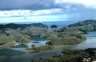
English: Aerial view of uplifted limestone islands, so called "Rock Islands" in Palau
Русский: Вид на острова архипелага Палау |
| Date | circa 1971 |
| Source |
|
| Author | Dr. James P. McVey, NOAA Sea Grant Program |
| Permission (Reusing this file) |
PD, see NOAA's About the Images |
Licensing
This image is in the public domain because it contains materials that originally came from the U.S. National Oceanic and Atmospheric Administration, taken or made as part of an employee's official duties.
|
File history
Click on a date/time to view the file as it appeared at that time.
| Date/Time | Thumbnail | Dimensions | User | Comment | |
|---|---|---|---|---|---|
| current | 17:25, 3 April 2008 | | 1,776 × 1,160 (1.22 MB) | Gugganij | {{Information |Description=Aerial view of uplifted limestone islands in Palau . Ca. 1971. |Source=*[http://www.photolib.noaa.gov/htmls/mvey0036.htm NOAA Photo Library - Aerial view of uplifted limestone islands in Palau] *Image ID: mvey0036, NOAA's Small |
File usage
The following page uses this file: